IMPORTANCE OF THE BARBICAN
MEETING WITH SOME OF THE PEOPLE INVOLVED IN THE HISTORICAL RESEARCH UNDERPINNING THE 400-YEAR COMMEMORATIONS LED US TO CONCLUDE THAT THE MAYFLOWER’S VOYAGE, ALTHOUGH OF HISTORICAL SIGNIFICANCE, WAS ONLY PART OF THE STORY.
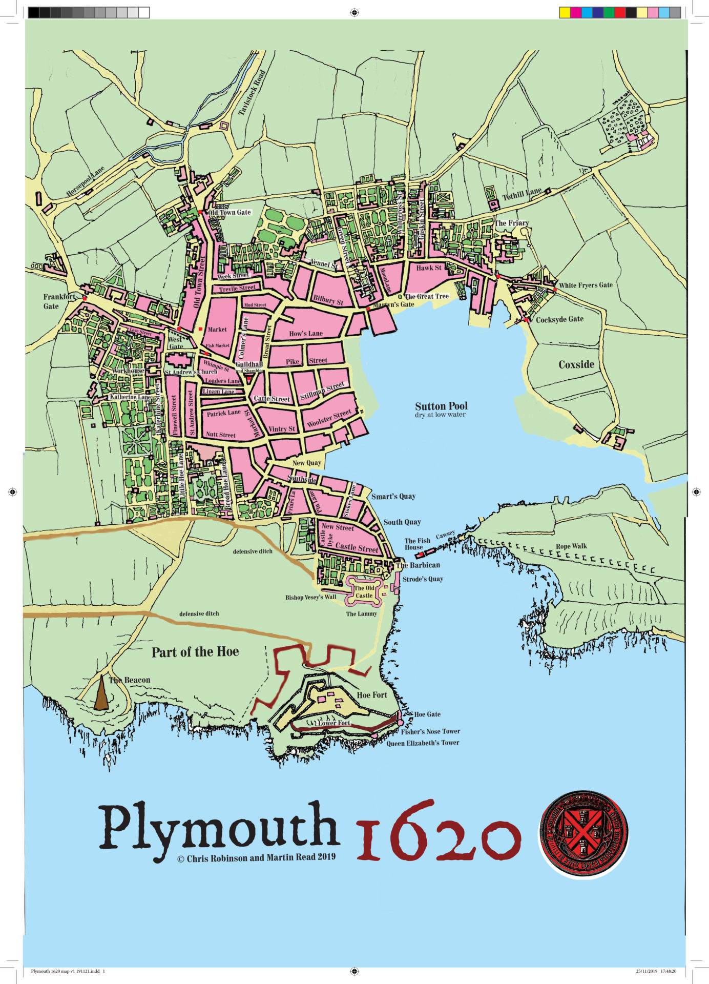
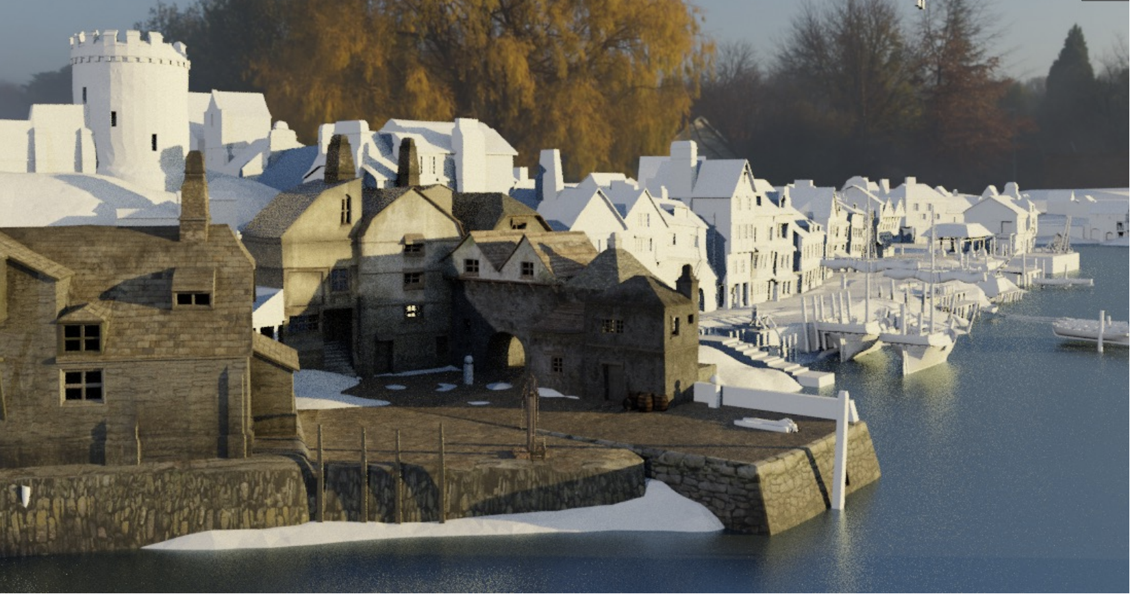
From a historical perspective, the harbour from which the ship departed on 16th September 1620, Plymouth’s famous Barbican was, we concluded, perhaps of equal, if not greater significance from the perspective of historical education. As a result, we decided to proceed with the Virtual Heritage effort, but to focus more on developing a 1620s model of the Barbican to complement the existing 3D model of the Mayflower.
One of the challenges of developing such a virtual environment is how to satisfy the many different voices that exist, especially within academia, each claiming that their vision of the layout of the harbour area is the correct one. This is not a new phenomenon in the Virtual Heritage arena. It has been our experience over the years, from sites on Dartmoor to wrecks in Plymouth Sound, that, no matter how hard one tries to research the best possible sources, there is always somebody who will disagree…typically coming out of the woodwork at the end of a project, when all the hard work has been completed!
Fortunately, in addition to our own research, we were able to engage with two personalities working in the Plymouth area at the time the Virtual Barbican project was coming together. These were Jo Loosemore (seconded to Plymouth’s main Museum, The Box, for Mayflower 400 support) and particularly Martin Read. Both have provided us with invaluable references and images and, whilst we are certain that there are parts of the final Virtual Barbican model that will need changing or refinement, we feel happy that we have capture the main details of the period, together with features that will have an educational value going forward.
To start with, our Historical Advisors advised us that we should focus on the maps/plans compiled in 1725 and held by the British Library by Benjamin Donn in 1765 (Hatfield’s map of 1592 was also mentioned, but available images were very unclear). Other maps were found during the course of the research, and are listed below.
REFERENCE BOOKS
- Eldred, C.E., & Wright, W.H.K. (1901), “Streets of Old Plymouth”; James H, Keys, 7, Whimple Street, Plymouth.
- Robinson, C. (2020), “Plymouth 1620 – This Being a Guide to the Principal Attractions and History of the Port”; Pen & Ink Publishing, 2019.
- “Plymouth’s Barbican and Castle: An Historic Landscape and its Archaeology”; Plymouth City Museum & Art Gallery, 2000.
- Stuart, E. (1991), “Lost Landscapes of Plymouth”; Sutton Publishing Ltd.
- Worth, R.N. (1893) “Calendar of the Plymouth Municipal Records”; University of California Libraries; pp.18-19.
- Wright W. H. K. (1909), “The Story of Plymouth for Young and Old”; Forgotten Books.
MAPS & ILLUSTRATION
- Sir Bernard de Gomme (1666/7 and 1672), Two plans of the Citadel at Plymouth – National Maritime Museum, Greenwich, London.
- An Exact Plan of the Royal Citadel and Town of Plymouth (1725).
- Donn (1765): “A Plan of the Town and Citadel of Plymouth”
- Wenceslas Hollar: “A Trve Mapp and Discription of the Towne of Plymouth and the Fortifications thereof with the workes and approaches of the Enemy at the last Siege AD 1643”
- “Plymouth Plan 1 and 2”; Plymouth & West Devon Records Office.
- Fortifications of Plymouth
- Steve Johnson’s Cyberheritage Site (various).
- Plymouth Town in the 1620s (a schematic developed by Historical Advisor and featured in Chris Robinson’s book, listed above).